SHOWERY TOR TO ROUGHTOR

SHOWERY TO ROUGHTOR

showery-tor-slopes-2

Cloud shadows sweep across the lower grassy slopes of the tor and the adjoining stretched moorland. Skylarks sing in constant chatter above the ancient open, expanse of grazed land. Drifts of early flowering grasses, sedge and rushes mix with granite outcrops, iron-age settlement remains and soon-to- flower swathes of turf sprinkled liberally with tormentil, flowering clover and the delicate, hardy alpines clinging within the cracks on the exposed granite.

Roughtor crowns the highest point of a long ridge which runs northwards, almost to the edges of Davidstow Moor and the spires and towers of the Davidstow Creamery. A reminder that we are never too far away from our consumer-led society. If you follow the ridgeline in this direction you come first to the stand-alone outcrop of Little Roughtor and the visible remains of an iron-age settlement, and beyond, again, lays Showery Tor, capped by a prominent cheesewring formation of balanced, piled rocks. From the summit of Showery Tor the eye-line spreads for miles and miles; to Pentire Head, standing guard at the mouth of the Camel Estuary on the North Cornish coast and west to the white ‘Cornish Alps’ rising over the rolling Roseland landscape of St Austell and on towards the vegetation clad spoil heaps of china clay at Stanton. Beyond the moor’s margins, sunlight cracks through distant clouds and highlight the cliffs of Dizzard Point and Crackington. Reflected light bounces off the Davidstow steel spires. But it’s the twin peaks of Brown Willy and the route Jane and I are on now, following the sloped razor-backed spine to Rough Tor’s pinnacle, that dominates this beautiful and remote part of the moor. The ridges and cheesewrings looming ahead like a vast toy jenga set. Looking down the sloping drop towards the Charlotte Dymond memorial, standing stones slump inwards on themselves, towards the boggy, waterlogged floor of cotton grass and sphagnum. It’s uncertain whether this ancient man-made formation originated as a Prehistoric ceremonial or ritualistic space, or is an early medieval livestock pound, but it is more than as likely a Bronze Age or Iron Age hut circle, making this one of the oldest constantly lived and worked landscapes in the British Isles.

Today, a herd of Highland Cattle graze around this stunning site and eye us both inquisitively as we pass them by. A small calf, no bigger than a fully grown hairy Rottweiler, takes the sheltered eastern flank of its mother’s, shiny and shaggy copper tinged coat. In the near distance a small group of ponies and 3 Foals nibble and tug at the short moorland grasses. The cows, ponies and a scattering of sheep populate this land, free to roam over unbounded moorland and the visible ghost-lines of ancient fields. The stream running along the foot of the grass-covered slopes cuts through many centuries of peat, and is bridged by lengths of granite protrusions, where, in the wetter margins and marshy hollows, foxgloves will sway rhythmically in the welcoming breeze on a warm summers day. Upslope the nooks and jagged teeth of the granite blocks and forgotten, part-carved millstones, abound with pollen-rich grasses, sorrel, and in the open, yellow vetch. On the skyline the ponies have moved effortlessly from the lower grassy slopes and now mingle with walkers, who, unlike us, are now making their way back to their car. We on the other hand ‘have promises to keep’ so we stride out further onto the welcoming moor – our flasks of coffee and flapjacks safe in our backpack, for now anyway…

Sam Josh Thomas

The Moot Point – Ockment Press

West Devon

An Ockment Morning

The cloudy wisps of sheep’s fleece that snagged on the golden gorse were full of pin-prick crystals this morning and were in the process of losing their mattress stuffing quality – the lanolin in the wool made the moisture hanging heavy in the atmosphere stand out like pearls. These gleamed and sparkled in the early morning light, giving the fleece a sprinkling of life as if it were a substance like fine fungal threads or root hairs feeding on the evaporating, lifting mists.

A wire boundary fence, overgrown with ragged hornbeam and flecks of sparse gorse, is strung along an ancient, foot-tamped Holloway, the soil worn away down to the granite bedrock after centuries of footfall from humans and farm-stock. Passing under the looming hulks of beech, sycamore and mature holly, it struck me that at this very moment in time, there appeared to be nothing, apart from me and the dog to keep either in or out… Just the occasional applause of a wood-pigeons wing clap reminded me that we did indeed have company… The field lay empty, the slopes showing the spread of granite boulders that lay hidden under the bracken most of the year, hauled clear from the ancient field systems by long-forgotten farmers and their even more, long-forgotten labourers. The dreariness of the wintered trees is backlit as if on a stage by the low pink glow of the rising sun; a sepia-toned murk with the horizon edges smudged out.

The landscape feels as if hypnotised.

A waxwing busied itself in a tree, feasting on a plump clump of ruby-red berries, as now white-tailed rabbits hopped and swaggered across the lower slopes of the open moorland. The blackbirds and robins abandoned their combined attempts to outsing each other and threw snatches of notes into the rising mists, picking at the still air like an avian John Motson – a constant, noisy stream of unmanaged noise talking ever louder over one another. New bursting shoots of cow parsley poke through the verges and primroses and snowdrops break the turf around the tree roots. This weather had carded the strands and clumps of sheep’s wool into swags whilst the mists had filled them with liquid treasures.

Fleece was used in ancient times by being laid into the flowing streams and filtering the water of all its mineral wealth – the particles of copper, tin, silver and gold: the very origin of the golden fleece. Today though the wool snagged on the wire and gorse sparkle unlike anything I have seen before and with the lifting mist, the day started to feel lighter as the gauze-covered sun rose, warming this Mid-February morning.

Sam Josh Thomas

The Moot Point West Devon

samjosh@ockmentpress.co.uk

Between The Moors

dartmoor-morning

November 2016

Today we awoke to see the full beginnings of winter in this quiet corner of West Devon; the trees now stripped of foliage and baring their skeletoned fingers into the cold, clear morning sky. Thick  brushings of frost coat the landscape, viewed from our windows, the thick ruched kingsize duvet protecting us from the icing sugar that had been blown from unseen lips over the rolling hillsides overnight.

Only a week ago browning coppered leaves still clung to the branch stems and the view across the moorland valley stretched no further than the end of our steep, stepped path; now though, through the twisted fingers of the entwined naked boughs our vision takes us further: across the tumbling River Ockment, across the peak of the crumbling crennalated Norman castle and on and up over the forestry commision pine plantation that is rooted into the far valley walls. To our right, through a wider gap the distant rolls of Exmoor smudge the grey-pencilled skyline, glowing now as Amber as the sun begins it’s journey. 

Yet if we were to walk 800m behind us, up the closely cropped grass-covered slopes, through the clumps of bronzed bracken and the scatter of granite clitter to the trig-point, we would see as far as the shadowed Bodmin Moor laying away, still, to the west; the twin peaks of Roughtor and Brown Willy rising through the frost covered grass-clad flanks.

Our only company would be the herd of Galloway cattle watching us inquisitively; my partner Jane, myself and the dog. Their belts of blacks and browns looking as if they haven’t pulled the skin far enough up over their bellies. Newly born calves the size of Labradors would be staring at us with those huge brown eyes, not knowing what we are as that warming winter sun rises and spreads its glow from behind the moorland ridgeline.

Maybe later, for now though we sink further into the duvet; it’s too nice and warm – maybe later we’ll take that walk…

Sam Josh Thomas

samjosh@ockmentpress.co.uk

Okehampton


I’VE BEEN THERE, AND BACK, AGAIN; TINTAGEL – WINTER 2015

1200px-bossiney_haven_panorama

A wide halo around new year’s moon portends stormier weather. Fields are already stogged: cattle feeding troughs mired in ponds of sloppy mud and arable fields gushing earthy water, streaming down sunken lanes and flooding across roads.

On the north coast, out beyond Tintagel’s guest houses, gift shops and plastic Excalibur’s, the heaving grey sea is flattened by an off-shore southerly wind. Above contorted slate cliffs the coastal path veers across sodden, poached pasture, up and down slate steps, slippery with trickling water.

Driest ground is on medieval fields and strips. Here bracken and turf thrive on well-drained ant hills, set in a hollow high above the wave-cut rocks, arches and sea stacks defending Willapark’s ancient cliff castle. A waterfall sprays out over Bossiney Haven and, further on, past dripping slate outcrops and thickets of bare blackthorn, a few white-faced bullocks shelter between yellow flowering gorse bushes, overlooking the deep cleft of Rocky Valley.

Down below, beneath crags draped with ivy, the stream races brown, to be overwhelmed by waves foaming up the narrow outfall. Later, weak sunlight gleams through the Ladies’ Window, Tintagel’s isolated church a dark shadow on the south-western horizon. Inland, up to a rough, watery lane, stands St Petrocs at Trevalga, its weather-beaten tower facing the ocean, Celtic cross hoary with lichen.

Lanes, slate stiles, and deep mud lead to St Nectan’s Kieve, hidden and secured behind gates, roaring within darkening woods floored with soggy leaf mould and sprawling ferns.

Higher up, past ranks of shut-up holiday caravans, last pale light merges sky and sea, distant Long Island towering above cliff-level, the rising moon a streaking of gold behind the thickening cloud.


© Sam Josh Thomas, 

Ockment Press Ltd.

Border Raid

BORDER RAID

llangattock

Below me, way below me, on one lonely side of the ridge, there are endless quiet miles of English countryside. The lightly rippling patchwork of an Edward Thomas landscape holds all the promises of the quiet, rural life, and in the distance, there are the enigmatic pencilled outlines of Elgar’s Malvern Hills and the beginnings of Houseman’s Shropshire and her own hilly range beyond. In the other direction, falling away along the ridgeline the promised picture is completely different: long, thick charcoaled smudges of whale-backed mountains lurk under a darkening cloud, impressive and austere, concealing the coalfields where my ancestors worked and lived for centuries (I remain the only one of my remote, strange family – if any survive, that talk in this anonymous, unsinging London accent). The great coastal cities and gateways lay beyond.

In this direction is the Land of My Fathers; Wales

The landscapes either side of the ridgeline could hardly do a better job of summing up the nominal character of the two nations; one polite and gentle, near pastoral really – a quintessential E.M. Forster environment. Whereas the other side could not be more different with a wild, craggy and indomitable vista running westwards to the Irish Sea. This ridge is the easternmost bulwark of the Black Mountains and the ancient border between England and Wales and matched physically by the line of Offa’s Dyke. Ideally, you need a full day of far-reaching visibility to fully appreciate the breathtaking drama laid out before you, but even on overcast grey days, it can deliver fully, on its promise. Today the cloud which marred the early morning has peeled away like a wrapper as I flop into the soft, sweet nutty scented heather to eat lunch and take my time to consume not just food but also the exquisite view; a bustling blue sky layers a shifting collage of shadow and sun onto the rich green pastoral landscape below me. Buzzards and kestrels hang above, suspended and wheeling on unseen wires.

The Black Mountains were once a fighting frontier on a par with the Antonine and Hadrian’s Wall along the Northumberland and Scottish borders; from where I stand now my Welsh ancestors have challenged and at times, rebuffed the invaders from over the border ranging from the Romans to the Anglo-Saxons to the proud, indomitable armies of Edward I. Maybe that’s why we charge so much to cross the bridge: We still try to keep the buggers out…

Today, ironically, these parts just happen to be one of the most anglicised parts of Wales thanks to a long line of baby-boomer ex-hippie incomers (I chose Cornwall as my escape route from London) yet that does little to affect the profound spirit of place which seeps out of every pore of this wonderful, evocative landscape.

Not far away, on and around the Llangattock escarpment, a thin crusting limestone outcrop buffers the sandstone country of the agricultural Black Mountains from the fossil fuels of coal country, and there are few better ways to experience this lesson in geopolitics, in how our culture grows from the ground, than cross over it and feel the atmospheric change with the geology beneath. Within any nation, there are many borders, many countries and many, many changes.

Everytime I come back to this borderland I can feel something inside of me ease and welcome me back in like a friend, and today is no different from before. The very first time I walked down the street to the River Usk in Cricklehowell I felt an unknown surge of contentment; there is something invisible but inexpressibly comforting in the rounded hills, the hawthorn, hedgerows and the sequestered valleys, reminiscent of Yorkshire but with the edges softened, a much softer accent and a welcome absence of Geoff Boycott.

Today herds of semi-wild ponies watch on quizzically as I walk on unfettered, for miles and miles under a warming spring sky that appears to grow ever wider and longer by the hour, until the golden glow of sun eventually softens and wanes. As I descend into the valley patterned with freshly budding hedgerows, it throws a rich golden honey light over the ‘Land of My Fathers’ and brings out the ruddy colour of the rich red, fecund earth under my feet.


Sam Josh Thomas

© Ockment Press Ltd 2016

North O’ The Moor

14691133_1306356966054757_7109912971531137802_n

The brilliance of the constellation Orion fades through the crystal clear morning with the onset of dawn. Calls from Tawny owls deflect from the tree-shrouded hillside above our moorland home, and the A30 carries the muted ‘whoosh’ of the commuting traffic speeding through the steep-sided road cutting. In the field adjoining home a rabbit ‘boinks’ across the dewy grass to the burrowed hedge banks: sheep huddle in the corner awaiting more light before fanning out to graze the greening moorland. The sky becomes bright pink, orange, and turquoise, with wisps of cloud crossed with nail scratches of condensation trails from jets, moving eastbound on the transatlantic flightline in quick 5-minute intervals.

On this fine autumnal morning once familiar views now appear as a succession of cut-outs or stage flats from a theatre backdrop. Below me now the ancient market town settles beneath the shelter of the valley walls, clothed in a mix of oak and pine and blanketed mist resembling a Dartmoor ‘Brigadoon’

Soon the landscape is flooded with a golden light that burnishes withered leaves on copper beech, sweet chestnut and sycamore, reflects on the glossy sylvan greens of ash and lifts and enhances the scarlet redness of the profusion of haw berries. Two buzzards wheel above me, undeterred by the harrying, thuggish jackdaws, but the dog and I remain oblivious now to their constant ‘kak-kak-kak’ cries, becoming as they do part of the senses; mixing imperceptibly with the visual and aural landscapes and contrasting perfectly with the steady hum of the road.

Sam Josh Thomas –

Ockment Press Ltd

(Photography – Jane Munro)

THE MOOR

gateway_and_track_beside_hatherleigh_lane_-_geograph-org-uk_-_256496


Harvesting cereals is fast these days, probably going unnoticed by many of the passers-by making their way towards Okehampton, close to my home. The golden stubble is glimpsed intermittently through the gaps in gateways and hedgerows off narrowing lanes, encompassed by ancient earthen banks tumbling with honeysuckle, sloes and hawthorn. Loaders, balers and trailers race and take positions on unseen starting grids to gather the big round straw bales before tonight’s forecasted rain arrives. Some uncut fields of the later spring-sown barley remain, awaiting the early autumn cut. This afternoon, up above the town,  this circular walk reveals the open, undulating panorama of fields and woodland over Dartmoor and Bodmin moor, partly obscured by the sun ‘drawing water’ from the hillsides. Cloud shadows wander lazily across the pastoral landscapes, where patches of sunlight enhance the emerald shaded shoots of regrowth in amongst the hay and silage fields and the luminous, warming glow of the blonde stubble and uncut corn.

Up here, just a few metres or so above the rooftops, clumps of tall, flowing grasses, coloured to straw contrast with the pinks, purples and oranges of ling, bell heather and crocosmia. Blackberries are ripening perfectly, staining my fingers as I snaffle a couple – the dog likes them too… A motley crew of cows and calves view us placidly, quietly chewing among the bracken and golden coconut scented gorse, masking the granite outcrops which freckle through the well-drained turf. On the hill’s northern flank, rowans with an abundance of scarlet red berries (a bad winter to come maybe?) Appear vivid before the hazy, lazy blues, greens and ‘Boris Johnson’ straw blondes of lower lands stretching over into the foreign lands of Launceston. A flock of pipits skim perfectly across the undulating hillsides, scattering southwards away from the plaintive mew and shadowed wings of buzzards.

Below me lays a now familiar territory of the green, smooth valleys and patchworked fields of arable and dairy enclosures around this West Devon market town. Shafts of welcome sun glint on the church tower down below me, nestling in the narrow lanes of my adopted home, drawing me back down to the self-imposed promise of a much-needed coffee.

Sam Josh Thomas

Ockment Press Ltd. West Devon

MORWENSTOW


LOOKING FOR HAWKER

Morwenstow Church

I am unable to count the number of times I have come here to Morwenstow, hidden away on North Cornwall’s wind-lashed shoulder. Whether this has been by some element of design, or by default I do not know, or whether I have been unwittingly drawn to the peace and quiet gothic solitude of the clifftop setting. Yet I usually find myself strolling through the wild, yet lovingly tended churchyard, drawn onwards by the tearful tranquillity before striking out across the footpaths that skirt the fields leading on to the coastpath route. There cannot be many churches anywhere in the UK within a more dramatic position than the one here at Morwenstow, nestling as it does on the edge of a small wooded valley that tumbles away to the sea just 800m from the churchyard walls.

The gaunt, razored sea-cliffs reflect perfectly the wildness that only these parts of the South West and far North West coastal regions know. Landscapes change accordingly through time’s arrow, as does the community and land wardens that work it, so when cresting the undulating clifftops that roll towards Sharpnose Point – a ridged promontory that juts into the Atlantic reaches – it is possible to experience it for yourself the changes in society and its cathedrals of worship and priority with the huge mushroom discs of GCHQ Cleve Camp rising in front of you; the satellite receivers cupping their ears to the sky and intercepting our once private communications.

The views stretch further than just the GCHQ station thankfully, the coastline meandering like a drunk southward down the jagged, razor-sharp slate grey fins to Tintagel, Pentire and The Rumps with a distant, muzzy Trevose Head at the mouth of the Camel Estuary.

Whilst off the footpath, hidden in the lee of the undulating, windswept and coconut-scented gorse covered clifftop, lays the smallest and probably most surprising of properties in the National Trust Portfolio. Facing out towards the open Atlantic and battered by the sea-born gales that smash into landfall Hawker’s Hut sits blanketed under encroaching turf sprouting Sea Thrift and sprinklings of Stonecrop, giving the feeling that it’s actually a ramshackle Hobbit shed hidden away in the crook of the cliff and was cobbled together from the wreckage of The Alonzo which floundered on the razored-rocks below in 1843.

Its builder remains a hero of mine: Rev Robert Stephen Hawker.

Morwenstow Hawkers Hut

In the truest sense of the word he was unique for his time and on his outlook towards the establishment, his loyal Parishioners and the unfortunate passengers, sailors and fishermen who would sometimes be washed-up, lifeless, on the near inaccessible beaches within the Parish boundaries. Thanks to Hawker and a handful of locals he would scramble down the precipitous, crumbling cliffs to rescue the remains of more than 40 sailors, burying them within the consecrated churchyard grounds. They were never to return to their homes, yet Hawker was able to give them a final resting place in an age when it was customary to bury sailors unceremoniously in unmarked pits on the beaches or cliffs close to where they came to rest, or just more often than not, left to rot in the water. He truly was a decent, compassionate man. The non-descript stone building next to the Lych-gate at the entrance to the churchyard, is more of a lean-to than a building to be honest, yet was originally the mortuary where Hawker stored the bodies prior to burial. (Lych coming from the old Saxon word for corpse). Just further down, beyond the Lych-gate stands a copy of the white figurehead of The Caledonia, which ran aground and was wrecked on the rocks of Sharpnose Point. Again, it was Hawker who risked his own life to retrieve the bodies.

Amongst his other introductions were the Harvest Festival, first celebrated in 1843. All his parishioners were formally invited to attend to give thanks ‘to God for providing such plenty’ after a few years of failed harvests. With bread made from the first cut corn it quickly caught on and spread through Cornwall, North Devon and beyond, whilst in Port Isaac, the ‘Doc Martin’ fishing village their festival celebrations included fish, fishing nets, oars, lobsters and crabs taking the place of the more traditional, vegetables, fruit, flowers and battered tins of Carnation Evaporated Milk…

People loved and respected him it seemed – visiting the village inhabitants with his pet Pig in tow, wearing un-cleric like garb of a purple coat, fisherman’s jersey and seaman’s boots, and also on a couple of occasions taking himself to nearby Bude and plopping himself on a rock disguised himself as a Mermaid. Well, who hasn’t?!

Even the vicarage became a reflection of his unique outlook, having the entire place rebuilt to his own design, including five very different chimneys – all modelled on churches in his life; Morwenstow, Welcombe, Tamerton (where he’d been a popular curate) and Magdalen College, Oxford. The kitchen chimney however is said to be a replica of his mother’s tomb. Now though the vicarage is in private hands but still stands proud abutting the churchyard, boasting unbroken views down the wooded Morwenna Valley and out to the untrusting sea. But it was the hut, this ramshackle, cobbled together Hobbit-like hut, speaks as much about him, as does his bravery in scrambling down steep inaccessible cliffs to retrieve the shipwrecked bodies’ He’d sit here for hours on end writing poetry, sermons and songs including Cornwall’s anthem ‘Song of The Western Men’ as well as letters and missives to his mourned, dead wife. All whilst smoking copious amounts of Opium… As you do.

He re-married again soon after, to a Polish governess who happened to be a good 20 years younger than him, and though this was to remain a happy union until his own death in 1875, he would still write to his first, long deceased wife.

1908480_7807ee07

 It’s such a steep, twisting and quite unsettling descent into the Tidna Valley from the coastpath above Hawker’s hut, yet it is so worth the effort if you can fight off the sometimes overwhelming desire to lose balance and stumble. The view out to sea of the remote and stunning Lundy Island; rising like a 400ft high granite Whale away at the mouth of the Bristol Channel, breeches the water and stands cloud and mist free today, looking magical from this distance. I can recall what I was once told by ‘an old Cornish salty seadog’ that “If you can’t see Lundy then it’s raining, if you can see Lundy then it’ll rain tomorrow.” On this occasion Captain Pugwash was wrong as it has remained sunny everyday since, and that was over a week ago…

Yet I knew I would be rewarded with the warming weather and the onset of a late spring bringing a multitude of wild flowers out of their wintered slumber. The open, salt-tinged, sea-sprayed banks are clothed with a delicate beauty such as Ling, Sheep’s Bit, Sea Carrot, Wild Thyme, Sea Campion and Thrift on the lower reaches. Sheltered from the harsh sea breezes, sunny banks encourage a rich variety of Butterflies, Moths, Slow Worms and invertebrates. Scarlet Tiger Moths are conspicuous in their daytime flights, their quietly spectacular markings lifting them out of the mixes of greens, yellows and blues of the flora but they are able to do so due them feeding on large amounts of Comfrey during the Larval Stages. Comfrey, though a widely used medicinal herb contains high levels of toxins in its leaves and roots, causing liver damage. So the Larvae extracts these chemicals and stores them as a defence making them bitter to taste which is why they can afford to be so big and flashy an insect. Walking further up the path, largely shaded from the overhead sun by Holm Oaks growing alongside the fast-flowing stream large clumps of Heather, Scabious, Comfrey, Kidney Vetch Birdsfoot Trefoil, Stonecrop, Sea Campion, Bluebells, Wild Ransoms and Three-Cornered Leek peak uncontrolled through the greening woodland trail floor. Ferns and Lichens join the blanketing woodland herbs, where the damp, cool atmosphere encourages rare fungi, Wood Sanicle, Enchanters Nightshade. Birdsong accompanies the quietness through the wooded valley, unseen voices echo with the song of Nuthatch, Blue Tit, Buzzard and are joined by early summer visitors of Willow Warbler, Garden Warbler, Spotted Flycatcher and my adored Skylarks, chattering constantly over the valley’s lower grass covered slopes.

At the lip of the Tidna Valley, the stream (The Tidna Chute) tumbles away down to the sea and the jutting Sharpnose Point, stands the Bush Inn (which I sat outside on many an unhappy family visit through the 70’s – as my parents got quietly smashed at the bar, I sat in isolation with a bottle of flat coke and a packet of damp crisps outside in the sun) which in itself has as long a history as the church site, dating back to 950AD when it is thought to have been the location of a ‘Monk’s or Pilgrims Rest’ on the Wales to Spain route of the Santiago Di Compostela. However, parts of the current building date back to 13th Century – roughly at the same time the church was being established – and reflect their connections still as a still visible Monastic Cross is carved into the flag-stoned floor, whilst in the main bar sits an ancient Celtic Piscina or shallow bowl carved from Serpentine, found way down to the South West of Cornwall on the Lizard.

Many of the older pubs usually have ‘Bush’ in their name, where a bough or bush was attached to the outside entrance which signified that a new fresh brew of Ale had been made or that a brewing house was on the premises, so before the ability to read and write became commonplace this was something ingenious as most people would be able to recognize this. Until a fire in 1968, the pub had a proud thatched roof, and was reputedly haunted by a friendly ghost but during the blaze an unknown figure was seen moving slowly away from the building and since then, no sightings of the ghost have been recorded.

But now, like the ghost and thankfully only seen to a few people on this bright, light sunny day I move quietly on, back to the 21st Century noises and distractions, taking with me that sense of freedom that this entire place, Morwenstow, always gives. A well-earned coffee beckons, dragging me towards the Old Rectory Tea Rooms and maybe a slab of cake to top-up my flagging sugar levels.

Once again, I am totally besotted with this place, which never fails to inspire and calm me.

© Sam Josh Thomas

 Ockment Press Ltd.

Holsworthy 2016

IT’S BEHIND YOU! (The Town, That Is…) – BACK TO TINTAGEL

Celtic Labyrinth - The Rocky Valley, Tintagel, North Cornwall

I have written about this place quite negatively in the past, focussing on the concrete square boxes that constitute architecture instead of looking as to what makes this section of landscape and coastpath so spectacularly beautiful in the extreme. Maybe it is because I associate the place with the dark remembered visits with my dysfunctional, unhappy family in the early 1970’s.

Somethings, I suppose, can’t help but linger in the memory…

Rediscovering the coastline, footpaths and narrow sunken lanes has been for me, a revelation, enabling me to cast aside my clouded memories and find a lightness and expanse to a landscape and town I’d often only associated with a grey dullness, tainted with bickering, alcohol infused unhappy parents. I never appreciated how exhilarating and breathtaking this stretch was before now and is something I shall never taint again.

Taking the winding lane opposite the blighted (sorry, force of habit),  wonderful car park I crossed the road making my way from the town and out to the church. The herringbone patterned stone hedgerows (or Curzyway in the local parlance) are a unique feature to this part of North Cornwall, and throughout this walk I was to brush against an abundance of sweet-smelling flora; Sea and Pink Campion, coconut scented Gorse, Foxglove, Valerian with its sweet pungent aroma, Common Toadflax, Bramble, May Blossom, Willowherb, Sheep’s Bit and Smooth Hawks-beard. Rounding the bend in the road, the parish church of St Materiana stands sentry in splendid isolation where it has guarded the headland from around 1080, its late Norman tower, squat, square and standing strong against all that the Atlantic can hurl at it. A beacon and waymarker to shipping, fishermen and walkers alike through the centuries. I walked over a ‘Cornish Stile’ comprising a stone cattle-grid and a coffin rest in the centre and I was immediately hit by a sense of peaceful solitude; only the combined sounds of the sea, Skylark birdsong and the distant ‘chugga-chugga’ of a diesel engine hidden behind field walls broke the otherwise immaculate silence.

Laid out before me was the true, undisputable history of Tintagel; not the legend of ‘Arthur’ imagined in the crumbling walls on the next headland over, but the real people who cultivated the surrounding landscapes, hauled the rocks from the fields, built the settlements and kept the town breathing through 1,500 years of life.

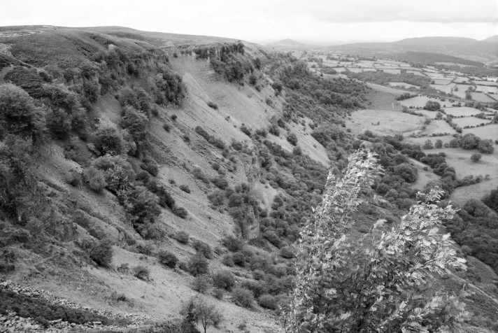
After a walk around the churchyard and watching an early Spring migrant, a Swallow, taking nesting refuge in the church porch, I made my way right and continued on towards the island and its castle ramparts, taking care not to get too close to the destabilized cliff edges riddled with crumbling slate quarry workings. Adjacent to this section of sublime coastpath are accessible, rocky outcrops of Devonian Slates (about 370million years old) These rocks and those of the fortified island have been disturbed, crumbled, folded and faulted and consequently the Geological time relationships between the Slates, Tuffs and Lavas of the Tintagel Volcanic Formation are jumbled and mixed in with one another and misfiled. As I continued on towards the causeway and the ruined castle, the path changed in difficulty becoming steeper and narrower and is not for the nervous, skirting near vertical drops.

Throwing caution to the wind as this was a day of atonement, I retraced my steps those darker times, and decided on entering the castle (for a charge not too dissimilar to the steepness of the cliffpath) but it was well worth it. Despite the claims of an Arthurian connection, the castle, or the remains of the castle we see laid out before us, is mostly of an 11th & 12th Century Norman origin with a few 6th Century buildings (known as the ‘northern ruins’) In Cornish Tintagel (Tyn-tagel) refers to a fortress of the narrow entrance. The ruined monastery dates from around 500 AD. Which is contemporary with the church across the headland.

The steps down and along to the island must be treacherous on damper, wetter days but under that day’s early April sun the warmth on my face urged me on, filing the memory of the recent winter months deep within and rediscovering the excitement of my childhood exploration, before adults tore it away and suppressed it. When I reached the top of the island, passing through the ruins on the way, exploring the long dead rooms and looking back along the castle’s isolation, my true reward was to be the unbroken, panoramic view of the flat, open ocean and stepped headlands down to the west.

Leaving the island after an hour’s exploration I headed down through the narrow, well-walked paths to Tintagel Haven which once provided sheltered anchorage for the export of Tin, Slate and imports of Coal, Timber and everyday goods. Yet maybe the most surprising trading commodity has to be the Wine and Olive Oil, imported from the Mediterranean and the Byzantine Empire. Even now archaeological digs on the island and surrounding settlements will unearth fragments of Byzantium pottery from Millennia ago. A redundant Whim, still in position above the beach, was part of the winch that was used to haul Slates and Tin Ore down to the ships berthed below in the safety of the harbour, but now sits crumpled and crumbling, abandoned to the elements; an apt metaphor that everything we see is temporary, there is no permanence – everything changes. I carried on along the winding, sea-sprayed paths above the beach and made my way across the wooden boardwalk that crosses the narrow fast flowing stream, running down the hill before cascading into a small waterfall, onto the rocky shores below.

The two caves that stand in the island’s towering cliff-face reflect much of the place’s legend and fact and add to the sense of atmosphere that sits heavy in the haven. The smaller of the two was excavated by hand in the Mid-19th century to locate seams of copper bearing ore, and though worked for several years failed to prove profitable so it was left to the elements and natures speedy reclaim. The larger though is more well-known and immediately transports you back into the myths and legends, being called ‘Merlin’s Cave’ after many references made to it in Arthurian stories. Now though, just in case any visitors should be mistaken of their whereabouts, English Heritage in their infinite, caretakerly wisdom have commissioned a large ‘Merlin-like’ relief to be carved into the rock-face unwittingly turning a stunning, natural haven into the beginnings of a glorified Arthurian Theme Park. Admittedly the actual work is pretty good and carved quite beautifully, but really… Not in this wonderfully evocative setting please? Just sell it with the other ‘New-Age’ tat up in some of the souvenir shops in the town.

A short walk up the valley, past the crumbling light green, coarse-grained slate and the warning of potential rockfalls, stands a small café and toilets and a steep path back to town. I only mention it to change the subject from English Heritage’s rock graffiti.

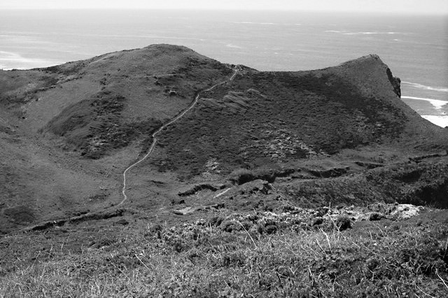
With that in mind I took to the steps and ascended the path out of the haven, leaving the carving and castle behind me and headed towards Barras Nose, its crumbling, spectacular promontory acting as a refuge. The geology here, for a self-confessed geek like me is truly fascinating with a mixture of cleaved, weathered rock types; Slates, Siltstones, with Volcanic Pillow Lavas and Tuff at its furthest reachable point, and is a great walking route, both easy to navigate and quite spectacular in its view yet treacherous underfoot in damp, wet weather. From here I followed the path that leads on towards Willapark (not to be confused with Boscastle’s Willapark a few miles up the coast – as in the Cornish language Willapark means ‘enclosure with a view’ so there are a couple of these place names in the Duchy). Passing above Barras Cove and Gullastem, I continued on, away from the old infected childhood memories stopping at a kissing gate, and brought back into the present, I am taken in by the constant chattering of the wonderful Skylarks and turn, looking back down to the island and on to the surrounding landscape. It’s then that I realised that, like Pavlov’s experiment I have mistakenly associated this entire place with a memory: a reminder of things past. So it’s not Tintagel that affects me in my loathing of the place but the ‘ringing bell’ left in memory by my parent’s that has remained with me.

Walking towards Willapark I could make out the ghost lines of the Iron-Age settlement laying in shallow relief across the open landscapes, most have been levelled and ploughed flat yet still the feint outlines remain. Just offshore, to the West, are The Little Sisters and Lye Rock, where on 20th December 1893 The Ion, carrying coal from Wales to Trinidad struck the jagged, razored rocks. Four local men braved the seas to save 9 sailors, but 3 others drowned including the cabin boy, Domenico Catanese, who’s grave sits in the quiet churchyard of St. Materiana, back at this walks beginning.

Facing East now I headed along the lower path around the small headland above Bossiney Haven. The steep, slippery steps heading down (and on outwards) to the Haven Valley are uneven and difficult underfoot, even when dry, yet the beach below is secluded yet popular with bathers, Kayakers and Cave explorer’s – and just as enjoyable is the fact that there is little in the way of mobile phone signal. Bliss…

Continuing on, I trip-trapped over a small wooden bridge, the steady flow of clean-looking, clear water reflected the sun’s rays into rivulets of silver. A four-way marker shows the path to the near empty beach, a return path to the main road to Tintagel via Bossiney Village, and the forward facing path to Boscastle. I chose the route less-travelled; sixty or so steep steps that lead out to the narrow valley to reach Bossiney Cliffs which made me realise why it didn’t look too well-trod so, by now, my legs were screaming for me to stop but to do that would mean starting again, so I carried on, a martyr to the lactic acid building in my calves. When at the far side, above the valley, I looked back on the route I’d taken and picked out the appropriately named ‘Elephant Rock’ stopping to take long, chilled drafts from my water-bottle and taking even longer, deep breaths.

This small journey was nearly over for today, coming to the returning point of the route, needing to get back to the car and then home again. Yet the feeling of closure within my conflicted relationship with my parents seems, at long last, to be careering to an end. Now that I have started to address the past, take responsibility and to try to understand what happened, instead of apportioning blame to them both. This walk along the damaged memories has helped me more than I expected it to and has come some way towards helping me reach my journey’s end.

Just over that hill now and I should be there.

Sam Josh Thomas


SPRING INTO SUMMER

SPRING INTO SUMMER

After a Winter that moved seamlessly from Summer, through Autumn and on into Spring, whilst leaving out the cold middleman, I felt we were due a period where we could at least get some use from the Ray-Bans. And the past week has, at least, enabled them finally to see some form of daylight and sunshine. Clear night skies have brought a coldness and welcome ground frosts to the dank mildness of the past few winter months, which in turn has given us unbroken blue skies. And this morning’s, over on Cornwall’s unblemished section of North coast is no exception.

Vehicles crowd into Port Isaac’s terraced car-park which overlooks a vast expanse of calming blue Ocean and the curve of imposing, shadowing cliffs north towards my own personal nemesis of the blighted, distant Tintagel. Seagulls perch on slated roofs encrusted with yellow Lichen, their cries far outdoing the chattering and heavy footsteps of visitors who stroll downhill, some dressed for walking and some just dressed for show, towards the enclosed sheltered haven.

Alongside the slipway, the old fish cellars used to be known as the Pilchard Palace in recognition of the tons of fish packed tightly into Hogshead barrels with salt and dispatched ‘up-country’ to those dark and distant foreign lands. This little port is much used as a film location and will be familiar to fans of ITV’S Doc Martin and the characters of the fictional Port Wenn. Also if you’re lucky you may get to hear the Fisherman’s Friends belting out some perfectly pitched and harmonized sea-shanty’s down on the working slipway.

            Today the Platt (a flat gathering place set above the high-water mark) is thronged with people making the most of the early spring sun, seated at tables sipping coffee and just looking happy that we are moving from the dark and into the lighter, longer days. Down on the beach, dogs’ splosh and paddle out from the pebble-strewn sandy shore, as children (and some adults it has to be said) play and skim stones across the receding, translucent calm water, oblivious to the ‘grown-ups’ above them on the Platt soaking in the sun.

Inland, up the steepening valley the sound of people, seagulls and general bustle fades away. Wrens, Chiffchaffs, Blackbirds and Blackcaps sing from the protection of Blackthorn, Bramble and Hawthorn thickets, wound through with Wild Fuchsia and Honeysuckle. Gorse flowers, perfumed like coconut and the rough pastures are sprinkled with Primroses, Violets and Celandines. Orange-Tip Butterflies flit gracefully towards Lady’s Smock and, in leafy copses, Bluebells will thrive as the Crocus and Snowdrops start to shrink away for another year.

 Ferns uncurl from their drenched winters sleep.

Up and away on the top fields, in sight of the sea and the Iron-Age Hillfort of the Rumps to the west, bullocks lay contentedly under the climbing sun. High above them the feint, distant chattering of Skylarks lifts my mood ever higher and a smile settles over my face. Out on the exposed coastal path, two Swallows, surprisingly early visitors, skim low over the greening turf starred with daisies.

Slate steps, edged with white bells of Three-Cornered Leek mark my return to the harbour and the sound of people still enjoying the sun and no doubt willing a long, warm Spring and Summer to come before we plunge headlong back into Winter’s cycle.

The Ray-Bans will get some use this year I think…